A new cold invasion is in full swing in most parts of the country, while from the evening – as stated in the new emergency report of the National Emergency Management Agency – there will be heavy snowfall in Attica regions.
According to the updated EMY emergency bulletin, the weather is worsening, with the main characteristics being a further drop in temperature and snowfall mainly from the heights of Thessaly in the eastern winds of the country and further south.
Stormy northerly winds prevail in the Aegean region with heavy rainfall and storms mainly in the central and southern sea-coast regions.
Especially for Attica, from the evening, snow falls in the lower altitudes (300-400m). These events will intensify from early Tuesday morning and snowfall will occur at lower elevations
More details:
A. Snow falls on:
a) Thessaly – Sporades: today Monday (29-01-24) in mountainous and semi-mountainous areas (mainly Magnesia) and in the evening and in low altitude areas (especially 200-300 m) from early morning on Tuesday (30-01-24) These phenomena intensify and gradually weaken at night.
b) Eastern Styria: Today Monday (29-01-24) in mountainous and semi-mountainous areas (mainly Viotia – Fithiodita) and in low altitude areas (reference 200-300m) from evening. These events will intensify from early morning on Tuesday (30-01-24) (mainly Boeotia) and will gradually weaken from early morning on Wednesday (31-01-24).
c) Evia: Today Monday (29-01-24) in mountainous and semi-mountainous areas in the evening and in low altitude areas (200-300m) these events will intensify from early morning on Tuesday (30-01-24) and on Wednesday (31-01 -24) They will gradually weaken from early morning.
Prophecy of Attica
d) Attica: Today Monday (29-01-24) in mountainous and semi-mountainous areas mainly in the north and in the evening and in low altitude areas (reference 300-400 m). These events will intensify from early morning on Tuesday (30-01-24) with snowfall mainly over eastern, northern and western regions even at lower elevations. Events will gradually weaken from night onwards.
e) Northern and Eastern Peloponnese: Today Monday in mountainous and semi-mountainous areas and from night and in areas with low altitude (300-400 m). Events will intensify temporarily on Tuesday (30-01-24) afternoon and weaken from Wednesday (31-01-24) morning.
f) Crete: Today Monday (29-01-24) in mountainous and semi-mountainous areas. These phenomena will intensify from Tuesday (30-01-24) morning and weaken from Wednesday (31-01-24) evening.
B. Northeast wind 9 and inland 10 Beaufort.
a) Tuesday (30-01-24) early in the morning in northern and gradually over central and southern Aegean regions.
b) On Wednesday (31-01-24) stormy northerly winds will be maintained in the Aegean, but from midday in the north they will be limited to 8 Beaufort and gradually weaken.
C. Heavy rain and storms are expected from early morning on Tuesday (30-01-24) mainly over Sporades, Evia, Cyclades and Crete. On Wednesday (31-01-24) these events will gradually weaken from the early afternoon over the Sporades, Evia and Cyclades and Crete.
Look at the drawings – where to put it
Weather maps 1 and 2 show the expected precipitation (shades of green) and snow (shades of purple) from the night of Monday 29/01 to Tuesday 30/01 and the morning of Tuesday 01/30.
Map 1. Rain (shades of green) and snow (shades of purple) expected overnight from Monday 01/29 to Tuesday 01/30
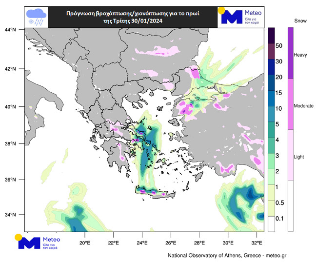
Figure 2. Rainfall (shades of green) and snow (shades of purple) expected for Tuesday 01/30 morning
Maps 3 and 4 show the amount of snow expected on the eastern mainland and Crete until midday on Wednesday 31/01.
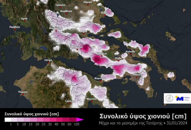
Map 3. Snow totals expected over the eastern mainland through Wednesday 01/31 afternoon
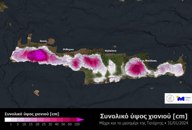
Chart 4. Total snow expected in Crete as of Wednesday 31/01 afternoon